Birding blog title
article goes here.
Ethiopian rift valley
The Great Rift Valley is a vast geographical and geological feature of East Africa and South West Asia created by the rifting and separation of the African and Arabian tectonic plates over 35 million years ago. This geological feature runs north to south for some 6000km from northern Syria to central Mozambique. The valley varies in width from 30-100km and in elevation from a few hundred meters to several thousand meters. The Rift Valley Lakes are a group of lakes formed by the Great Rift Valley of Eastern Africa. These lakes include some of the oldest, largest and deepest lakes in the world and are a fresh water region of great biodiversity. The Ethiopian Rift Valley offers eight spectacular chains of lakes. These formed during the period of high rainfall in the quaternary era when much of the world near the poles was covered in ice. Some of the lakes formed during that time are: Ziway, Langano, Abiata-Shala in the north and Abaya Chamo in the southern part of Ethiopia.
As the earth's climate gradually warmed in recent geological times, the Rift Valley lakes receded leaving extensive deposits of sedimentary rocks, making the Rift Valley an area of intense geological interest.
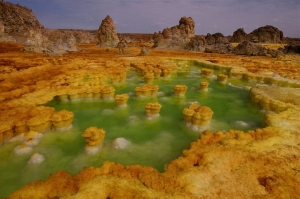
Arta’le & Danakil depression
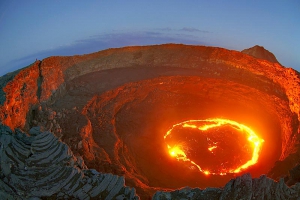
Over geological time, the northern part of the Great Rift Valley has formed a triangular basin between the Danakil Desert and the Afar Plain that today holds some of the most astounding terrain in the Horn of Africa.
Visit the Dallol one of the hottest areas on earth home to the Afar tribe of Ethiopia. Witness the age old activity of salt cutting, then accompany the camels on part of their three day trek, back up to Mekele to the Salt Market. View the live volcano of Ataele by night, an unforgettable experience.
Siemen Mountains NP
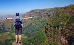
The Simien is definitely the most beautiful mountain range in Africa. Vast and unique, the highland plateau is capped by a dramatic skyline of jagged volcanic plugs and split by deep gorges and gullies. The views across this landscape are breathtaking: the striking towers and formations having been described as 'the chess pieces of the Gods'. Our trek takes us to both the highland and rural lowland areas, with an ascent of Ras Dashen, the highest peak in Ethiopia at 4543m, and the fourth highest in Africa.
A haven too many endemic species of flora and wildlife, including the gorgeous Gelada Baboon (heart blooded baboon) and Walia Ibex and many other interesting mammals .The Simien National Park has been declared a World Heritage Site by UNESCO.
Harar
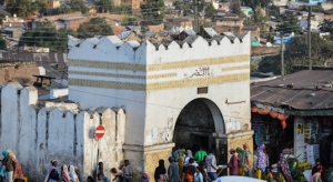
The fortified historic town of Harar is located in the eastern part of Ethiopia, 525 km from the capital of Addis Ababa, on a plateau with deep gorges surrounded by deserts and savannah. The walls surrounding this sacred city, considered “the fourth holy city” of Islam, were built between the 13th and 16th centuries and served as a protective barrier. There were five historic gates, which corresponded to the main roads to the town and also served to divide the city into five neighbourhoods, but this division is not functional anymore. The Harar gate, from where the main streets lead to the centre, is of recent construction.
Harar Jugol numbers 82 mosques, three of which date from the 10th century, 102 shrines and a number of traditional, Indian and combined townhouses with unique interior designs, which constitute a spectacular part of Harar's cultural heritage. The African and Islamic traditions influenced over a long period of time the development of the city and its typical urban planning and contributed to its particular character and uniqueness. The present urban layout follows the 16th century design for an Islamic town with its central core occupied with commercial and religious buildings and a maze of narrow alleyways with imposing facades.
The traditional Harari house has a typical, specific and original architectural form, different from the domestic layout usually known in Muslim countries, although reminiscent of the coastal Arab architecture, and with an exceptional interior design. At the end of the 19thcentury Indian merchants built new houses with wooden verandas that defined a different urban landscape and influenced the construction of the combined Indian/Harari houses. Their architectural and ornamental qualities are now part of the Harari cultural heritage. Harar functioned as the capital of the Harari Kingdom from 1520 to 1568, became an independent emirate in the 17th century and was integrated into Ethiopia in 1887. From the late 16th century to the 19th century Harar was an important trade centre between the coast and the interior highlands and a location for Islamic learning.
Gondar
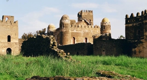
From kings and churches to emperors and castles: another not-to-be-missed stop on Ethiopia's Historic Route is what has been called the 'Camelot' of Africa: Gondar. Gondar is a Royal and ancient historical city of Ethiopia. It is the home of many Emperors and Princess who lead the country from the 12th century to the last decade of the 20th century. To mention just a few, Emperor Suseneos, Emperor Fasiledes, Empress Mentwab, Iyasu I, Tewodros II, Empress Taitu. It is the home of the highest mountain in Ethiopia, Ras Dashen, and the Simien Mountains National Park.
It is easy to imagine the intrigue and pageantry that took place back in the seventeenth and eighteenth centuries, when Gondar, then the Ethiopian capital, was home to a number of emperors and warlords, courtiers and kings. One only has to stroll through the banqueting halls and gaze down from the balconies of the many castles and palaces here to drift back into a long-ago world of battles and court conspiracies.
Nestled in the foothills of the Simien Mountains in north western Ethiopia, Gondar became the capital during the reign of Emperor Fasilidas (1632-1667), who built the first of a number of castle-like palaces to be found here. He established a tradition that was followed by most of his successors, whose buildings greatly enhanced the city's grandeur.
Gondar, which rose to prominence after Ethiopia went through a long period without a fixed capital, emerged in the seventeenth century as the country's largest settlement. In its day, the city was an important administrative, commercial, religious, and cultural centre. It was famous for its sophisticated aristocratic life, its church scholarship, and its extensive trade, which took its merchants to Sudan and the port of Massawa as well as to the rich lands south of the Blue Nile. Gondar was also noted for the skill of its many craftsmen.
The city retained its pre-eminence until the middle of the nineteenth century, when Emperor Tewodros II moved his seat of Government to Debre Tabor and later to Mekdela. As a result, Gondar declined greatly in importance and was subsequently looted in the 1880s by the Sudanese Dervishes. By the early nineteenth century the city was a mere shadow of its former self. More recently, its appearance was not aided by the fact that several historic buildings were damaged by British bombs during Ethiopia's liberation campaign of 1941. Most of Gondar's famous castles and other imperial buildings nevertheless survived the ravages of time: and together constitute one of Ethiopia's most fascinating antiquities.
Bahirdar
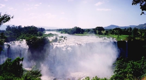
Bahirdar is a town set on the south - eastern shore of lake Tana, where local fishermen still use papyrus boats, and just 30 km from the spectacular Tissisat Falls. Here the Blue Nile creates “Smoking Water" an awe-inspiring sight as it plunges into the gorge below.
From Bahirdar one must explore some of the ancient monasteries that have been built around Lake Tana, or on the many Islands. The colorful local market at Bahirdar is renowned for its weavers and woodworkers.
Lake Tana, the largest lake, in Ethiopia is the source and from where the famed Blue Nile starts its long journey to Khartoum, and on to the Mediterranean. The 37 islands that are scattered about the surface of the Lake shelter fascinating churches and monasteries, some of which have histories dating back to the 13th Century. However, it should be noted that most of the religious houses are not open to women. The most interesting islands are: Birgida Mariam, Dega Estefanous, Narga, Tana Cherkos, Mitsele Fasiledes, Kebran and Debre Mariam.
Axum
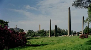
Aksum is perhaps most famous and well known by the mysterious stelaes. It is also the alleged resting place of the biblical Ark of the Covenant and the purported home of the legendary Queen of Sheba. The Kingdom of Aksum or Axum, also known as the Aksumite Empire was an important trading nation in northeastern Africa, ruled from approximately 100–940 AD. The Empire of Aksum at its height extended across most of present-day Eritrea, northern Ethiopia, Yemen, southern Saudi Arabia and northern Sudan. The capital city of the empire was Aksum, now in northern Ethiopia. The Kingdom used the name "Ethiopia" as early as the 4th century.
The Aksum Empire was named as one of the four great powers of the world along with Persia, Rome, and China. Aksum’s prosperity seems to have peaked in the late 3rd and early 4th centuries AD. Monumental royal tombs were constructed, each marked by a huge monolithic stela carved to represent a multi-storied building. Around the same time, Aksum began to produce its own coinage, with gold used for international trade, and copper and silver for local circulation. In about AD 340, the Aksumite kingdom formally adopted Christianity under king Ezana (320–360 AD), becoming only the second nation in the world (after Armenia) to do this.
Lalibela
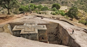
Lalibela is one of Ethiopia's holiest places, dating back to the 12th century. Lalibela town, formerly known as Roha, named after one of Ethiopian ruler, King Lalibela (1181-1221), a member of the Zagwe dynasty. Lalibela is known by the amazing eleven churches hewn from solid rock. Built in the twelfth century, they are still standing in excellent condition. Most consider them as the eighth wonder of the world, and is one of the world heritage sites listed by UNESCO.
The famous Lalibela churches carved out from the rock on which they stand. Some lie almost completely hidden in deep trenches, while others stand in open quarried caves. A complex and amazing labyrinth of tunnels and narrow passage ways connects them all.
Seeing all of the Lalibela churches are well worth it - particularly during the colourful Ethiopian christian holidays: Genna, Ethiopian Christmas (on January 7th) and Timkat, Epiphany (on January 19th).
History of Laibela
Lalibela is located in northern Ethiopia, about 500 miles [800 kilometers] north of Addis Ababa and halfway up on Roha Mountain. Legend says that Lalibela has visited Jerusalem and vowed to build a New Jerusalem as his capital in response to the capture of old Jerusalem by Muslims in 1187.The rock churches, although connected to one another by maze-like tunnels, are physically separated by a small river which is called the Jordan. Churches on one side of the Jordan represent the earthly Jerusalem; whereas those on the other side represent the heavenly Jerusalem, the city of jewels and golden sidewalks alluded to in the Bible.
Coffee and Culture
The rarely visited Southwest region of Gambella is an excellent alternative for cultural tourism for travelers who have already been to the tribal villages of South Omo or who prefer to see something less affected by mass tourism.
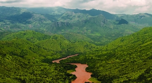
This off-the-beaten-track takes visitors through the middle of Oromia, passing first through the Gurage region southwest of Addis Ababa and then through the Gibe river valley to Jimma, an evergreen region of Ethiopia steeped in culture and history.
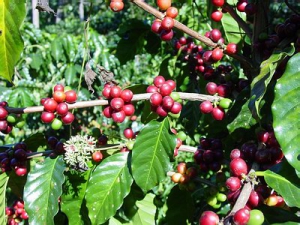
Spend the afternoon in Ethiopia’s largest coffee plantation in the same mountains where coffee Arabica was first discovered. Here you will see how Ethiopians grow, harvest and produce coffee for export as well as for the domestic market.
The tour continues through the green highlands of the Oromo region where most locals grow and harvest their own coffee. Day three takes visitors to the Sor Waterfall, once of Ethiopia’s biggest, for lunch on the banks of the Sor river. The half-day trek gives travelers a chance to stretch their legs and hike away from the main road.
By the fourth day, the group descends to an altitude of 500 meters to the city of Gambella. Here the Baró river ambles through the town and locals are attuned to a slower pace of life matched with the river.
The next two days are spent on day-tours outside of Gambella visiting Nuer and Anuwak villages. The two tribes have been sharing the Gambella area for centuries and until recently have not always lived peacefully. Recently, the tribesmen have struck a peace agreement and for the last several years, the quality of life has increased.
The Southwest of Ethiopia is a tour through a region of Ethiopia unaccustomed to tour groups and photography. The tribes of Gambella continue to exhibit a purity of interest in visitors showing the same interest in their customs and trades. Come and test organic coffee
Specialization
VIP tour with charter flight, Bird watching tour, Butterfly tour, Filming and Photography, Organizing MICE tourism, Company/School outing, Safari and Wildlife tour, Study tour, Camping, Trekking, Air Ticketing, Hotel booking, and Car renting/Hire.
Contact Information
Please feel free to reach us using the following address.
Mobile: +251-929-901-860
Phone: +251-113-714-494
Email: reservation@begohatours.com
Bole Atlas Road, Cape Verde Street, Opposite to Desalegn Hotel or Near to European Union Delegation office ,
P.O.Box 100512 Addis Ababa, Ethiopia
Stay Connected
Proud member of:

Sister Companies:
